I had recently seen some beautiful pictures from the Schoharie Creek Preserve, and we decided to make a trip out to the preserve to hike the 1.3 mile trail.
We used Google Maps to find the preserve, but we ended up going on a major detour. Coming from the Albany area, we headed west on Route 20. Google Maps put us up the East side of the Schoharie Creek and crossing it on Braman’s Corners road. However, the bridge over the creek is completely out. We had to go all the way back to Route 20 and back up the West side of Schoharie Creek (through Esperance near Landis Arboretum), adding at least 15 minutes to our drive. The bridge doesn’t look anywhere near done, so keep this in mind if you plan a trip out from the Albany area.
When we arrived at the preserve, there is a single lane dirt drive leading to the parking lot, and unfortunately it was full with about 6 cars. We ended up hiking another area before heading back later. I do wish there was more parking here, especially since it is not located near much of anything or any other Mohawk Hudson Land Conservancy Preserves.
The preserve has a trailhead with information on the preserve. I always make sure I save a trail map on my phone before heading out to a trail.

The trail is a short 1.3 mile loop. You can view the full trail map here.

We headed out on the trail, which starts off near a pond.

The trail is fairly well-marked with blue markers throughout.


This beginning part of the trail runs parallel to Wilsey Creek. There is a long embankment going down to the creek, so we did not head down, and I was disappointed to miss out on seeing quite a few nice cascades along the way. I did see a lot of people scaling the banks, but I try to stay on marked trails, and I don’t want to take chances with the kids.
The trail comes to a stop at a higher falls, and turns around. You can just see the falls through the trees.
There is this bench, but no trail signage after it. (This photo is looking back at the trail).

There are a few small logs laying down, but does not provide much of a barrier.

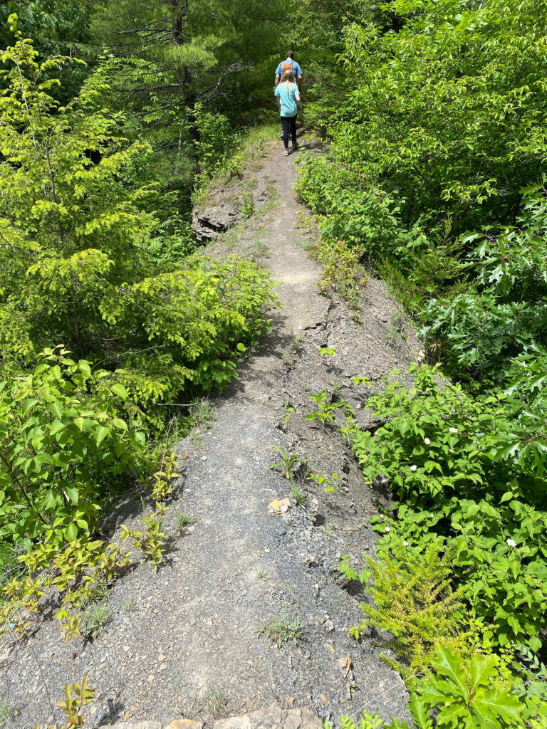
This was a rather nerve-wracking portion that we checked out, which becomes a narrow trail that drops off at least 40′ on each side. The trail and stone surfaces are all covered in little pieces of rocks, making it all very slippery.
You can see right in the middle of this photo where the trail is only a few inches wide, and is eroded off each side.
While I came to the conclusion that this is not part of the designated trail, there were no signs saying not to go further, and there was an old metal ladder propped up on the rocks, which seems to encourage people to walk this path.

We turned around, went back to the bench, and back on the trail, we continued through the woods.

The trail crosses Butler Road two times. While it doesn’t seem like a particularly busy road, we were very cautious, especially crossing with the kids.

We reached Schoharie Creek, about the halfway mark of the trail loop.

The creek was a nice place to stop and explore. We saw so many tadpoles starting to get their legs, and lots of crayfish and small fish. It is always nice to have a creek along a trail, because it gives us the chance for the kids to be engaged in nature.


We had a nice time visiting the preserve, with the highlight being able to explore Schoharie reek. The trail is an easy 1.3 mile loop. There were a few steep spots, but they were relatively short sections.
I do wish there was better parking, and a trail down to Wilsey Creek so that we could check out the various casades.

Visit the preserve on the Mohawk Hudson Land Conservancy page here:
https://mohawkhudson.org/our-preserves/schoharie-creek-preserve/
Check out the other Albany area hikes we have done:
https://www.anationofmoms.com/travel/albany-ny-hikes
This isn’t far off the route I follow when I drive to visit family. I might have to make it a stop along the way next time!
Seems like auch a beautiful place, hope to travel soon
This looks like it was an amazing trip. Beautiful scenery to look at on the hike.
This is the kind of place that I could spend all day at. I grew up in the south, so being out in nature like this is one of my favorite things. It’s beautiful!
We love Schoharie Creek! We go there whenever we can during the summer and fall. It’s so beautiful, and we have so much fun.
I love a good walk through a wooded area! We don’t have many such areas here in southwest Texas- I wish there were more.
You always find the best places to explore. I would love to take my kids.
Wow what a beautiful piece of nature. Looks like a gorgeous place for a summer hike. I bet it looks beautiful in all seasons too.
What a lovely time outside. All the places that you visit with your kids are so beautiful. I envy you, I hope I can take my kids to the outdoors, too.
The trail seems amazing…I love trekking a lot and always try my best to explore new trails. I would love to try out this trail.
This looks like an amazing place. I go to new york often and would be a nice stop!
this is a great bonding place to go to! closer to nature!
This seems like a great place to walk. My kids would love looking for tadpoles and crayfish in the creek.
It seems what a nice and great adventure i love the nature place…hope i can travel like this
This looks like a beautiful hike! I’m sure my daughter would love to find a crayfish.
really enjoyed my read & viewing all the photos shared here. I miss being with nature & outdoor, wish I can resume my trail activities soon, cheers, siennylovesdrawing
Schoharie Creek Preserve looks like heaven! I hope I can visit this place. Maybe after the pandemic?
The Schoharie Creek Preserve looks like an amazing place to hike. I need to get outdoors more and go on more hikes with my family for exercise and peace of mind.
Happy that you enjoyed your mini-hike. Photos are beautiful but I was thinking that it looks like so many trails that I’ve been on that if I was dropped in, I would not have any idea which park/forest I was in 🙂
Been itching to go out and travel again. Looking at the pictures makes me wanna go too! Definitely a good way to unwind for a while.
The Schoharie Creek Preserve looks like a great place to explore! I’d love to visit this place. Great shots ??
You are so brave for going down that slippery bit! Looks like a nice trail.